|
|
The feasibility of operating an Ultra Wideband Synthetic Aperture Radar
(UWB SAR)
from an airship for
the detection of mined areas in a humanitarian role.
Presented at the 3rd International Airship Convention
Friedrichshafen, Germany
3 July 2000
Author: Simon Christoforato
Air Systems DERA Farnborough, Farnborough.
Co-authors: Paul Bishop, Chris Thornhill, Sensors & Electronics DERA Malvern.
Abstract
The Defence Evaluation and Research Agency (DERA) and The Lightship Group (TLG) have conducted a trial with an A60+ airship and an innovative prototype radar system built by DERA. The aim of the trial was to investigate the feasibility of operating an Ultra Wideband Synthetic Aperture Radar (UWB SAR) from an airship for the detection of mined areas in a humanitarian role.
Flight trials were conducted at DERA Pershore, Worcestershire, UK during January 2000. During this period the system was flown for 15 hours and over 35 Gb of data were collected.
This paper describes the project background, gives details of the UWB SAR system and the trial
installation, shows preliminary results from the flight trials and outlines the way
forward.
Introduction
Land mines are a serious problem in many areas of the world. According to the UN, there are at least 60 million landmines around the world and some 25,000 people are maimed or killed annually (70 people daily). The Landmine Monitor also estimates that there are currently more than 250 million antipersonnel mines stored in the arsenals of at least 104 countries. UN records show that the use of some 900,000 square kilometres are unusable due to the presence of mines; this is the equivalent to a useable space the size of France and Germany combined.
There are currently no operational airborne humanitarian landmine survey systems. DERA and TLG believe that airships offer the following benefits over conventional aircraft operating in this role:
A mobile, stable platform,
long endurance,
low noise and vibration,
no downwash,
relatively large payload capability,
good operator environment.
Project Background
In 1998 DERA teamed with TLG to study the use of airships in a humanitarian mine detection role.
DERA is an agency of the United Kingdom Ministry of Defence (MOD). It is one of Europe's largest research organisations with a turnover of approximately Ј1 billion and about 12,000 staff. Experts were drawn from a range of disciplines across the organisation for this project, including mine detection technologies, RF techniques and airship systems integration.
TLG provided an A60+ airship for the trials. TLG is the world's largest airship operating company. They currently operate airships all over the world including Europe, North America, South America, Africa, Asia and Australia.
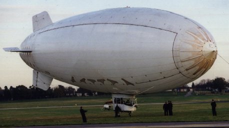
The A60+ airship that was used during the trials is a 40 metre long helium filled non rigid design manufactured by American Blimp Corporation (ABC). The airship is used primarily for advertising and aerial TV work. Figure 1 shows an A60+ airship.
|
|
Ultra Wide Band Synthetic Aperture Radar (UWB SAR)
Conventional radar is not optimised for mined area detection. In order to achieve the resolution required to detect anti-personnel landmines, a very high operating frequency is required. However, ground and foliage penetration is only achievable using low frequencies, with consequently low resolution.
In comparison, exceptionally high resolution is achievable using UWB radar. The accuracy to which the landmine range can be determined is related to the transmitted pulse duration. To detect very small landmines it is necessary to be able to determine the round trip time of the radar energy very accurately and in order to achieve this a very short pulse is used. The pulse occupies just a few centimetres in space; the range resolution achieved is comparable to this pulse width.
Additionally, as the radar is based on a moving platform the forward motion of the airship is exploited to form a "Synthetic Aperture". This is where the forward movement of a physically small antenna simulates a large antenna, giving greater cross range resolution. Signal processing is then used to convert the data into a composite image.
The UWB SAR prototype system developed by DERA has an instantaneous bandwidth of approximately 3GHz. This is believed to be the highest bandwidth, highest resolution radar of its type in the world.
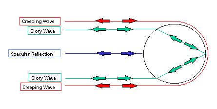
The targets scatter some energy at all frequencies within this wide bandwidth, providing information on the shape and material of the target. Figure 2 shows the dominant UWB scattering mechanisms associated with a dielectric cylinder:
|
|
The specular reflection is from the front surface of the target, the glory wave is due to the radar energy being coupled into the interior of the mine itself and reflecting off of its internal surfaces and the creeping wave is from around the target.
These scattering mechanisms provide unique signatures for each target. This is very important for
effective discrimination and classification of targets.
UWB SAR Installation
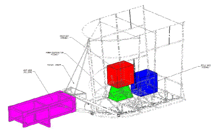
During the feasibility study the UWB SAR was installed on an A60+ airship. The A60+ gondola is relatively small (five seats including the pilot) and does not have seat tracks so mounting the equipment inside the gondola was not easy.
The installation consisted of two "19 inch" racks, one mounted on the floor and one mounted on the co-pilots seat. A central electrical distribution rack was mounted below the co-pilots seat. An external 2.5 kW APU mounted at the rear of the gondola generated all the electrical power for the system. The antenna installation was mounted on the standard camera mount at the front of the gondola.
Figure 4 shows the general assembly of the installation.
|
|
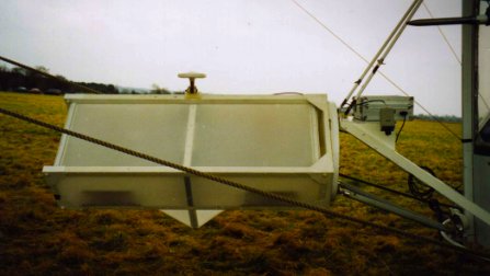
Figure 5 shows a picture of the antenna assembly. On top of the assembly is a GPS antenna, used in differential mode along with a ground station to accurately record the airship position (a requirement of Synthetic Aperture Radar). To the right of the antenna is the pulse source in a screened enclosure and a video camera for imaging the scene.
|
|
As metal affects the performance of the radar, metal fixtures on the antenna housing and mount were kept to a minimum. The transmit antenna was mounted nearest the gondola with the receive antenna on the other side. Electromagnetic Compatibility (EMC) tests confirmed that this arrangement did not cause any interference to the airship systems or avionics. The A60+ is a relatively basic design, with no advanced Flight Control Systems (FCS) or avionics, this made it an ideal trials vehicle.
The total weight of the system was 221 kg and the electrical power requirement was 1.9 KW.
The installation was cleared by ABC (American Blimp Company) and was flown under a FAA
Experimental Register.
Trials
Flight trials were conducted at DERA Pershore, Worcestershire, UK during January 2000. The aim of the trial was to investigate the feasibility of operating an UWB SAR from an airship for the detection of mined areas in a humanitarian role.
Initial measurements were made against marker sets (trihedrals and metallic spheres) on tarmac. These were used as calibration measurements and enabled the performance of the system to be quantified. Measurements were made at different heights and speeds until the optimum setup for the trial configuration was established.
Measurements were then made against target sets that consisted of metallic and plastic mines and mine like targets of varying sizes. The smallest of the targets was only 10cm in diameter and entirely plastic.
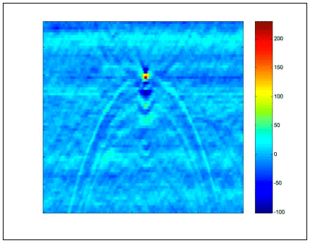
Figure 6 shows a focused image of a metal mine-like target. The target is clearly discernible in the centre of the image. In this case the dominant scatterer is the front surface of the metal target, the specular reflection.
|
|
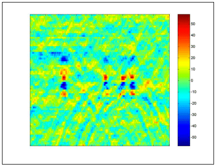
Figure 7 shows a focused image of four plastic mine-like targets and shows distinct differences from the metal mine in the last figure. The plastic targets are again clearly discernible. The earliest returns are at the top of the image with range extending downwards. The radar receives the majority of the energy over an elongated period of time for this target type. The first return shown is due to the specular reflection from the plastic mine and the largest return, later in time is due to the Glory Wave.
|
|
These were the first airborne trials of this type of UWB SAR in the world. The trials were very successful
with the system performing at least as well as previous ground based trials; the airship proved to be
an excellent platform. A considerable amount of data was collected which is currently being analysed and
will be used in the development of an operational system.
Current de-mining procedures
Before considering how this system could be utilised in humanitarian operations, it is important to review current de-mining survey procedures.
The UN have produced international standards for humanitarian mine clearance operations [1] which provides a framework for Standard Operating Procedures (SOP). This gives details for survey and mine clearance operations.
In order to establish a Mine Action Plan (MAP), areas that are suspected of being mined must be quickly identified. These records form part of the mine survey database and are a major planning tool in the prioritisation of tasks and the commitment of mine clearance resources.
There are three levels of survey:
Level One: General Survey
Level Two: Technical Survey
Level Three: Completion Survey
The objective of a Level One (General Survey) is to collect information on the general locations of suspected or mined areas. Information must be collected about the areas affected by mines or Unexploded Ordnance (UXO) and areas that are not affected. Areas must be categorised and the reliability and credibility of the data recorded.
The objective of a Level Two (Technical Survey) is to determine and delineate the perimeter of mined locations initially identified by the Level One survey. The marked perimeter forms the area for future mine clearance operations. The Level Two survey requires trained and properly equipped mine clearance personnel with the necessary skills to undertake and accurately record the survey work. Where possible, with time and resources permitting, these teams should also undertake area reduction work in order to accurately define the outer perimeters of the minefield.
The Level Three Completion Survey is conducted in conjunction with the mine clearance teams and accurately records the area cleared.
A major problem in current mine clearance operations is the time spent carrying out Level Two surveys. Inaccurate information leads to some 80% of areas being wrongly designated so that mined areas remain unreliably mapped, or worse, unidentified hence risking lives and leaving potential farming land unusable.
Colonel Alistair McAslan of the International Centre for Humanitarian De-mining in Geneva has summarised
the problem in the following statement. "First, we need better equipment and procedures to identify,
to map and to mark the outer edge of mined areas, as the early liberation of safe land provides hope and
encouragement. Second, we need better equipment and procedures to conduct quality control of cleared
land. An effective detection system, mounted on a low flying platform such as an airship, may offer
the solution to both of these challenges."
Way forward
The trial has clearly shown the potential for an airship system to assist in Level Two Technical Surveys. It is expected that the system will be able to uniquely map mined areas quickly and safely, covering ground at a rate equivalent to more than 100 square metres per second. This is many thousands of times faster than the average rate for a manual search.
The system also has the potential to support Level One assessments through to Level Three completion surveys.
An operational airship radar system, called Mineseeker, is being developed as a joint venture between
DERA and TLG. Commercial sponsorship is being sought so that the significant advances in UWB technology
that DERA has made in recent years can be incorporated into the system.
Summary
Land mines are a serious problem in many areas of the world. Currently there are no effective mined area detection systems. Due to their unique characteristics airships are an excellent platform for this role.
UWB SAR is an extremely promising technology that has the ability to penetrate foliage and the ground in order to detect metal and plastic mines. It gives unique information that provides better detection and discrimination of targets. The prototype system developed by DERA is believed to be the highest bandwidth, highest resolution radar of its type in the world.
These were the first airborne trials of this type of UWB SAR in the world. The trials proved that the system could be operated from an airship with the system performing at least as well as previous ground based trials; the airship proved to be an excellent platform.
A major problem in current mine clearance operations is the time spent in Level 2 (Technical Surveys). Inaccurate information leads to some 80% of areas being wrongly designated so that mined areas remain unreliably mapped, or worse, unidentified.
Commercial sponsorship is being sought so that the airship Mineseeker system can be developed to meet
the specific requirements of mined area detection in a humanitarian role.
References
United Nations Mine Action Service (UNMAS), International Standards for Humanitarian Mine Clearance Operations.
© British Crown Copyright, 2000
Published with the permission of the Defence Evaluation and Research Agency on behalf of the Controller
of HMSO.
![]()
Вернуться на предыдущую страницу
![]()
© Текст - Собственность Британской Короны,
2000; оформление - Станислав Фёдоров, 2001.
Последнее обновление - 04.02.01